Japan Braces for Supertyphoon Neoguri – landslides, floods may effect supply chain and military operations in region
Message From Marine Expeditionary Force/Marine Corps Installations Pacific
The typhoon comes on the tail end of Japan’s summer rainy season, and landslide warnings already are in effect for some areas due to those seasonal downpours.

Okinawa is home to a large U.S. military presence and is frequently in the path of typhoons. The island’s infrastructure is generally more resilient to storms compared with other areas in Japan.
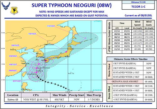
Kadena Air Base, Japan, evacuated all aircraft Sunday in preparation for Supertyphoon Neoguri, expected to hit Okinawa early Tuesday, which is late Monday U.S. time.
“I can’t stress enough how dangerous this typhoon may be when it hits Okinawa,” Brig. Gen. James Hecker, commander of the 18th Wing, said in a message to the Kadena community. “This is the most powerful typhoon forecast to hit the island in 15 years; we expect damaging winds to arrive by early Tuesday morning.”
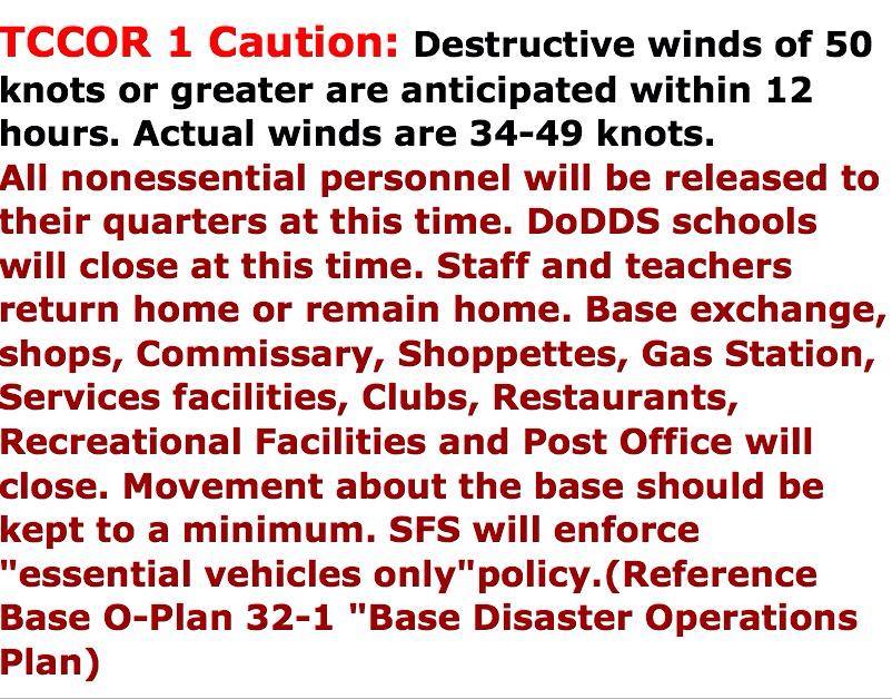
The base evacuated all of its aircraft to other bases in the region, and the base is in Tropical Cyclone Conditions of Readiness 1, meaning destructive winds of 50 knots or greater are expected within 12 hours, the base posted in an update on Facebook.
Personnel on base have been directed to fill any available containers with water and make a final check of food and other supplies.
“This is not just another typhoon. If we follow the typhoon procedures and take care of each other, we will all make it through this typhoon safely,” Hecker said in his message.
Supertyphoon Neoguri is expected to hit Okinawa early Tuesday with sustained winds of 198 kilometers per hour, equivalent to 123 mph and a Category 3 hurricane. The Japan Meterological Agency said the storm could generate waves up to 46 feet high.
To respond to the typhoon, the state minister in charge of disaster management, Keiji Furuya, canceled a trip to the U.S. that was to begin Tuesday. The crisis management center at the prime minister’s office also set up a special office to share information among ministries.
“I ask citizens to pay careful attention to the latest weather information and typhoon warnings,” the government’s main spokesman, Yoshihide Suga, told reporters Monday, urging people to prepare to evacuate if necessary.
After passing Okinawa, the typhoon is expected to turn eastward Wednesday morning toward Kagoshima on Japan’s southernmost main island of Kyushu, bringing heavy rains and winds. Kyushu has already been pummeled by rain since Sunday, prompting the meteorological agency to issue landslide warnings in some areas.
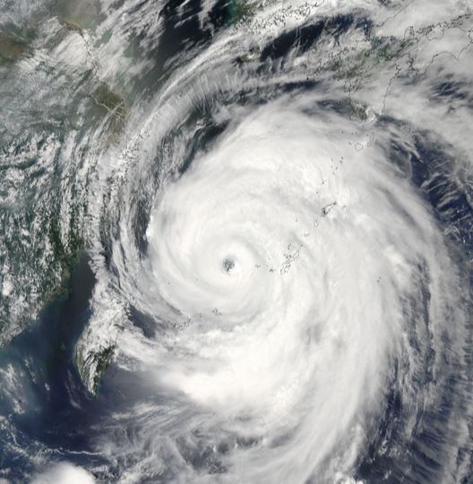
The U.S. Joint Typhoon Warning Center has designated Neoguri a “super-typhoon,” a category it uses for typhoons with winds more than 240 kph.
Tropical Cyclone Conditions of Readiness, or TCCOR, is the system that is used by the United State Navy here in Japan to help prepare for destructive weather from a Tropical Cyclone, or Typhoon.
TCCOR 4: Lowest stage. Indicates that a possible threat of destructive winds will occur in 72 hours.
TCCOR 3: Destructive Winds are possible within 48 hours.
TCCOR 2: Destructive winds are anticipated in 24 hours.
TCCOR 1: Destructive winds are anticipated within 12 hours.
What does that mean for you and your family?
When you hear that TCCOR 4 is set, you should evaluate your preparation. If you do not already have enough food and water set aside for a day or two, take care of it. Do not hoard, but anticipate what you need.
TCCOR 3: means we are getting closer to storm time. What do you have outside that needs to be put away (bikes, grills, toys, etc. )? It will blow away or cause damage if not taken care of.
TCCOR 2: means only essential personnel should be moving around base.
TCCOR 1: The storm is here! Do not go outside! This is NOT a time for cool YouTube videos. All those things that people did not fasten down in TCCOR 4 are now flying around. Wait it out.
ALL CLEAR: Wait for the all Clear before you go outside. Emergency personnel need to make sure everything is safe before you wander out so no one is injured from debris and any fallen power lines, trees, etc.
NMCB 1 – Naval Mobile Construction Battalion 1
Camp Shields officer in charge Master Chief Benno Lederer said that because of NMCB 1’s efforts in preparing for the typhoon, Camp Shields is braced for the storm well ahead of schedule.
“All NMCB 1 and 30th Naval Construction Regiment typhoon preparations are done and we are prepared for the storm,” said Lederer. “We will begin lock down for late (Monday, or early Tuesday) and are expected to be in that state until late Wednesday or Thursday.
Google Crisis Map: http://www.google.org/crisismap/japan
From The Japan Times:
Japan’s weather agency on Monday extended its highest alert to Okinawa’s populous main island as super typhoon Neoguri approached the southern chain, saying it may be one of the worst storms for decades.
The top-level warning means the typhoon poses a threat to life and could inflict massive damage from gusts of up to 270 kilometers per hour and torrential rain.
There are about 1.2 million residents on the main island. An earlier alert only covered the Miyako Island region with a population of 53,000.
Waves could reach as high as 14 meters, an official of the Japan Meteorological Agency said in a warning that was likely to revive memories of Japan’s quake-tsunami disaster in 2011.
 The typhoon was some 500 km south of the main Okinawan island at 1200 GMT and was moving north northwest at 25 kph.
Miyako Island, in the central area of the archipelago, was in the expected path of the massive storm.
“Record-level violent winds and high waves are posing a serious danger to the Miyako Island region,” Satoshi Ebihara, the agency’s chief weather forecaster, told an evening news conference.
“People are advised to refrain from going outdoors . . . evacuate if necessary before violent winds occur and take appropriate action to protect themselves,” he said.
The massive gusts and torrential rain will possibly reach mainland Japan by Wednesday, an weather agency official said earlier Monday.
Update 7/10/2014:
Tropical Storm Neoguri, previously the strongest typhoon so far in the 2014 Western Pacific season, is now scraping mainland Japan after raking Okinawa with torrential rain and hurricane-force winds.
According to the Japanese Meteorological Agency, Neoguri’s center made landfall near the city of Akune in Kagoshima Prefecture just before 7 a.m. Japanese time Thursday (6 p.m. Wednesday Eastern time in the U.S.). Akune is on the west coast of Kyushu, the southwestern most of Japan’s four main islands.
Maximum 10-minute sustained winds were estimated at 60 mph at the time of landfall, equivalent to maximum winds of 65 to 70 mph using the U.S. 1-minute sustained wind standard.
In Okinawa, heavy rainfall triggered flash flooding, prompting the Japanese Meteorological Society to reissue an “emergency warning” for landslides and damaging floods for the prefecture, having downgraded it earlier after the typhoon’s eye had moved north. The city of Nago on Okinawa Island reported 17.24 inches (438.0 mm) of rain between 9:10 a.m. Tuesday and 9:10 a.m. Wednesday local time.
A Twitter user in Nago posted photos of floodwaters swamping the city of 60,000 Wednesday morning, warning residents of his or her native Miyazaki Prefecture that this was coming their way.
From Stripes.com: CAMP FOSTER, Okinawa — Typhoon Neoguri bore down on mainland Japan on Wednesday after drenching the country’s southern islands with the heaviest rainfall in 10 years.
The storm felled tree limbs and caused significant power outages, flooding and an unknown number of injuries on Okinawa, according to U.S. military officials, who were still compiling damage reports for each base on the island.
On Tuesday afternoon, the typhoon battered the island, where about 30,000 U.S. troops are stationed, with heavy rain and wind gusts of up to 90-100 mph. More than 17 inches of rain drenched northern Okinawa, while the south got 15 inches
Satellite Animations
- Storm-Centered Infrared (MTSAT2; NOAA/SSD)
- Storm-Centered Infrared (Aviation Color Enhancement) (MTSAT2; NOAA/SSD)
- Storm-Centered Water Vapor (MTSAT2; NOAA/SSD)
- Storm-Centered Visible (MTSAT2; NOAA/SSD)
- Storm-Centered Visible (Colorized) (MTSAT2; NOAA/SSD)
- Storm-Centered Infrared (MTSAT2; CIMSS)
- Storm-Centered Enhanced Infrared (MTSAT2; CIMSS)
- Storm-Centered Water Vapor (MTSAT2; CIMSS)
- Storm-Centered Visible (MTSAT2; CIMSS)
- Tropical West Pacific Infrared (MTSAT2; NOAA)
- Tropical West Pacific Enhanced Infrared (MTSAT2; NOAA)
- Tropical West Pacific Water Vapor (MTSAT2; NOAA)
- Tropical West Pacific Visible (MTSAT2; NOAA)
Sources: various weather service and news reports
 “What should we do now?” “What should we say?”